
Historic Districts in Mission Hills
A historic district is defined in the City of San Diego’s Municipal Code as “a significant concentration, linkage, or continuity of sites, buildings, structures, or objects that are united historically, geographically, or aesthetically by plan or physical development and that have a special character, historical interest, cultural or aesthetic value, or that represents one or more architectural periods or styles in the history and development of the City.” Historic Districts can be designated the local level (City of San Diego) but can also be designated and listed with the State of California and/or at the Federal level with the National Register of Historic Places.
The benefits and restrictions of historic districts depend on the level of designation (City, State or National), but the primary objectives at all three levels are to preserve neighborhoods by protecting the basic characteristics and architectural features of contributing homes, discourage demolitions and encourage re-investment into such homes. Studies have shown that property values increase in historic districts and designation at the local level also allows owners of contributing homes to obtain property tax relief through the Mills Act.
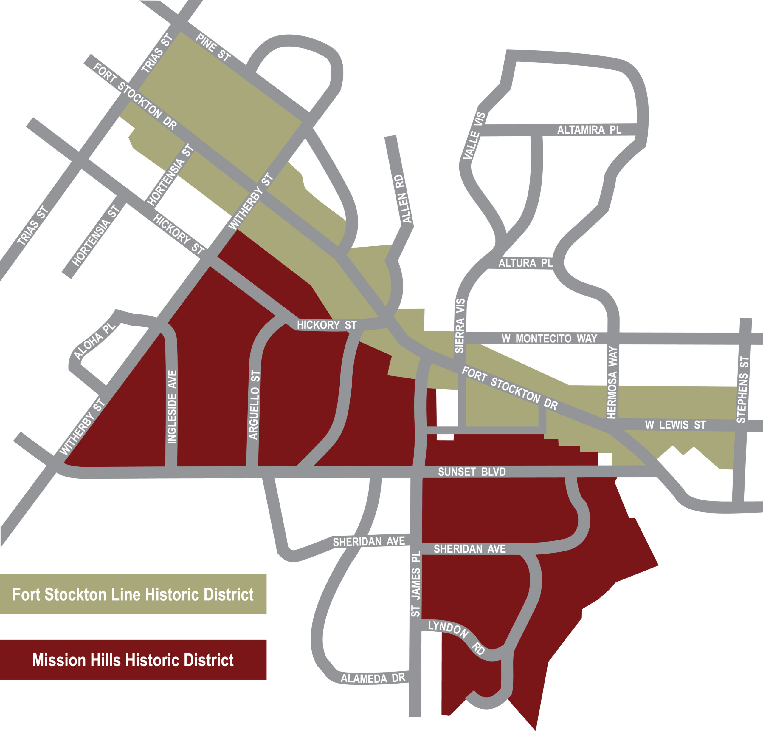
The Mission Hills Historic District and Fort Stockton Line Historic District were the first two historic districts in the Mission Hills Neighborhood and are both designated at the local level with the City of San Diego in 2007. The nominations for both districts were prepared by local Mission Hills residents in a community driven process.
Mission Hills Historic District:
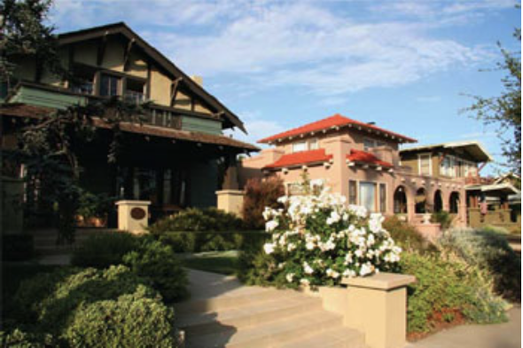
This district is a portion of the original Mission Hills subdivision map filed by George Marston and others in 1908 and consists of 75 homes along the 1800 block of Sunset Blvd, Sheridan Ave. and Lyndon Road. The district was approved by the Historic Resources Board in July 2007. The decision was upheld by the City Council in January 2008 following an appeal.
Fort Stockton Line Historic District:
This district follows the final extension of Streetcar Line No. 3 in 1913 and consists of 107 homes along parts of Fort Stockton Drive, West Lewis and Pine Street The district was approved by the Historic Resources Board in July 2007. It was not appealed and became effective 10 days later.
Mission Hills Historic District Extension
(Annex)
On June 26, 2014, the City’s Historic Resources Board (HRB) approved an expansion of the Mission Hill Historic District, adding 99 homes to the district. The expansion area boundaries are Sunset Boulevard on the south, Witherby Street on the west, Hickory Street (both sides) on the north, and St. James Place on the east. (See map below.) The extension area falls entirely within the first Mission Hills Subdivision. The HRB approval follows a several year effort by a team of residents living in the area.
Click here for a map of the locally designated historic districts in Mission Hills.
A historic district is defined in the City of San Diego’s Municipal Code as “a significant concentration, linkage, or continuity of sites, buildings, structures, or objects that are united historically, geographically, or aesthetically by plan or physical development and that have a special character, historical interest, cultural or aesthetic value, or that represents one or more architectural periods or styles in the history and development of the City.” Historic Districts can be designated the local level (City of San Diego) but can also be designated and listed with the State of California and/or at the Federal level with the National Register of Historic Places.
The benefits and restrictions of historic districts depend on the level of designation (City, State or National), but the primary objectives at all three levels are to preserve neighborhoods by protecting the basic characteristics and architectural features of contributing homes, discourage demolitions and encourage re-investment into such homes. Studies have shown that property values increase in historic districts and designation at the local level also allows owners of contributing homes to obtain property tax relief through the Mills Act.
The Mission Hills Historic District and Fort Stockton Line Historic District were the first two historic districts in the Mission Hills Neighborhood and are both designated at the local level with the City of San Diego in 2007. The nominations for both districts were prepared by local Mission Hills residents in a community driven process.
Mission Hills Historic District:
This district is a portion of the original Mission Hills subdivision map filed by George Marston and others in 1908 and consists of 75 homes along the 1800 block of Sunset Blvd, Sheridan Ave. and Lyndon Road. The district was approved by the Historic Resources Board in July 2007. The decision was upheld by the City Council in January 2008 following an appeal.
Inspiration Heights
This historic district is based on the Inspiration Heights subdivision map filed by Harry L. Miller in 1909, which was based on the earlier Johnston Heights subdivision map filed by his mother, Sarah Johnston (Cox) Miller, in 1886. The district is roughly bounded by Sunset Boulevard on the north, St. James Place on the east, Witherby Street on the west, and includes Orizaba Street, Miller Street and portions of Arden Way, Bandini Street and Couts. With assistance from MHH, a committee of residents began exploring the potential for designating this historic district in 2009. The committee hired a consultant, prepared a historic district nomination proposal and submitted to the City a draft of a context statement for the potential Inspiration Heights historic district. Unfortunately, the effort stalled in 2013 when the City shifted away from community driven nominations of historic districts. However, in 2020 MHH decided to renew the effort, this time by seeking listing on the National Register. MHH hired a consultant and filed a nomination report with the State Office of Historic Preservation, which processes nominations to the National Register. The State Historic Resources Commission approved the nomination in October 2021 and Inspiration Heights was formally placed on the National Register of Historic Places in December 2021. Mission Hills Heritage also intends to pursue designation at the local level, which does not require any additional report. Upon listing at the local level, property tax relief will be available to contributing homes.
Click here for a location map of the Inspiration Heights Historic District.
FUTURE MISSION HILLS HISTORIC DISTRICTS
The City’s Planning staff has mapped out a larger potential Mission Hills Historic District, based on the entire area of the original Mission Hills subdivision map. This potential district may eventually encompass all of the original Mission Hills subdivision maps recorded in 1908 by George Marston and his partners. Additionally, several other potential historic districts have been identified for the Mission Hills area. In 2015, the City updated a historic survey of the Uptown area and identified 19 potential historic districts for all of Uptown, of which 8 are located in Mission Hills. Community groups, including Mission Hills Heritage, also identified additional potential districts, which have not yet been included in the City’s list of potential historic districts. In the fall of 2016, during the hearing process for approval of the Uptown Community Plan Update (Uptown CPU), the City deleted Presidio Hills from the list of potential districts due, leaving seven potential districts in Mission Hills.
Click here for a map of potential historic districts in Uptown and Mission Hills.
While the City does not have a schedule for implementing the identified potential historic districts, Mission Hills Heritage plans to continue pushing for approval of these districts.